
geopulse-ai
Where Location Meets Intelligence
Geopulse enables advanced analytics by combining Europe’s most extensive geospatial database with AI-driven technology.
20M+ Locations Classified
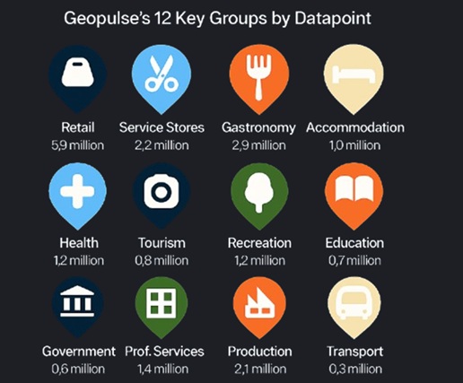
Geopulse‑ai offers Europe’s largest and nearly complete geo‑database, integrating over 20 million geocoded business and POI records. Covering almost every sector and region, each datapoint is classified into 12 groups, 144 subgroups and 950 detailed categories.
Hyperlocal Spatial Insights
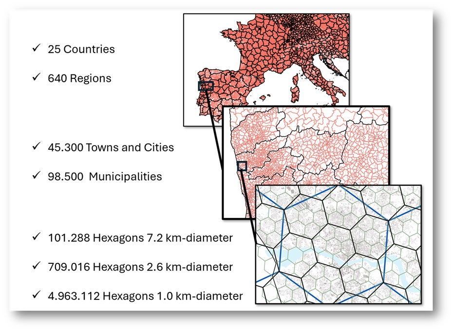
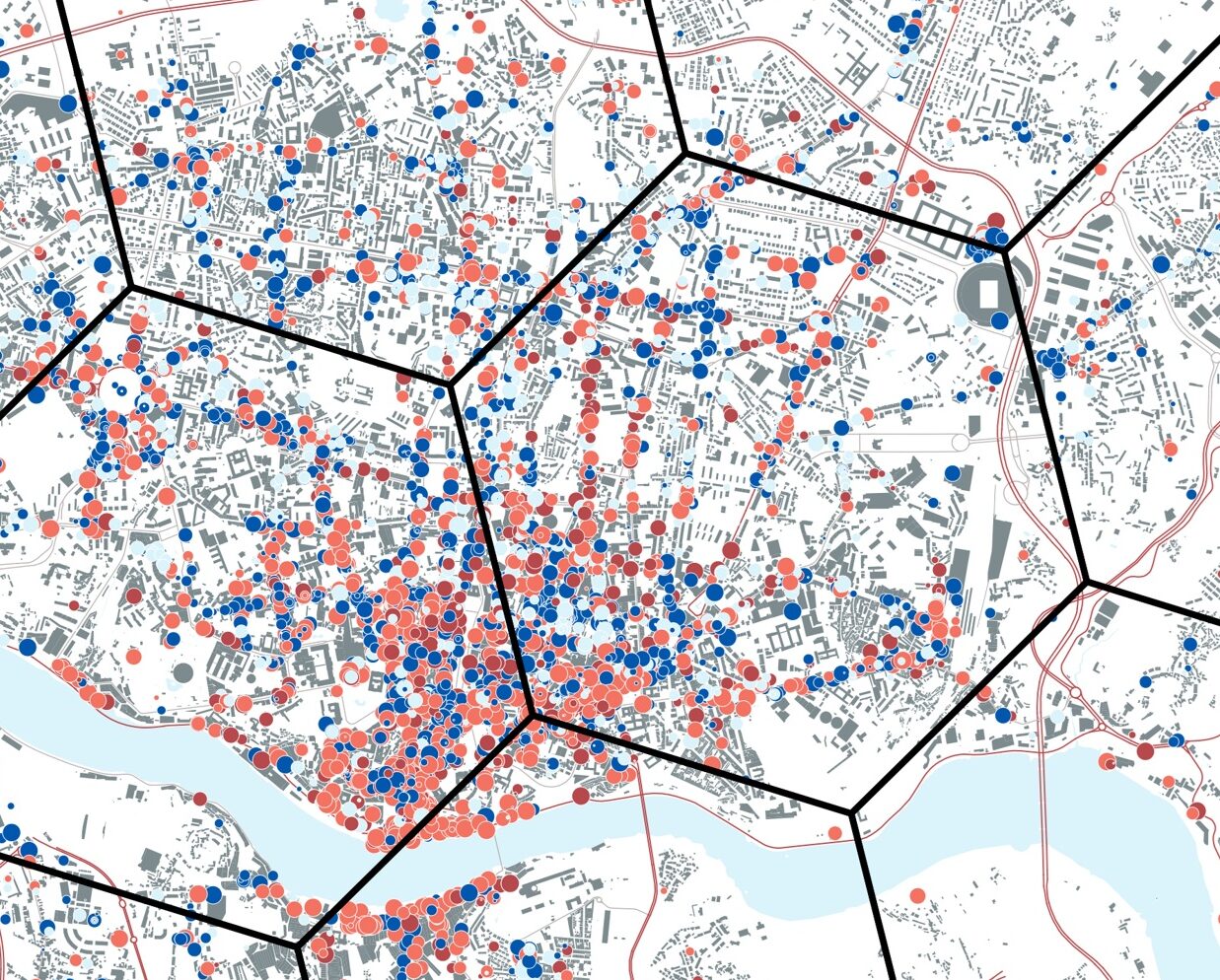
Our database lets you analyze every datapoint across multiple geographic layers—from official European regions and municipalities to the highly granular H3 grid, reaching 460‑meter hexagons. This structure delivers precise population data and unlocks powerful hyperlocal, scalable insights.
Detailed Local Intelligence
With every location classified into 12 groups, 144 subgroups, and over 950 detailed categories, our platform enables deep structural analysis of any region across Europe. By integrating demographic and economic data, users can explore the unique composition of cities, municipalities, or hexagonal zones. Advanced AI tools automatically identify comparable areas from our multi-million record database, enabling precise benchmarking and pattern recognition across similar territories. These insights support smarter decisions in market strategy, public policy, investment targeting, and spatial planning.
Geopulse Retail
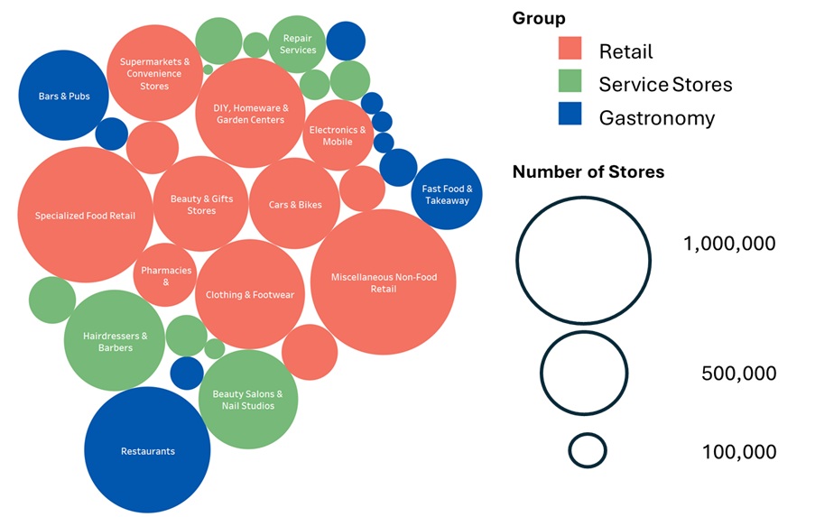
Geopulse offers Europe’s largest retailers database, featuring 3 million+ retailers and over 3,000 brands across 400 sub‑branches in 27 countries. All retail brands are updated quarterly, ensuring accurate tracking of market developments and providing companies with reliable, up‑to‑date insights for strategic decision‑making.
Business Applications
Our structured location intelligence unlocks actionable insights across key industries. From commercial strategy to spatial planning, each business area benefits from tailored data and precision analytics.
Real Estate
Assess location potential with demographic, economic, and categorical context. From site selection to portfolio optimization, our data-driven approach supports valuation, investment strategy, and risk analysis.
Retail
Optimize store networks, identify underserved markets, and benchmark performance against comparable zones. Our platform reveals hyperlocal consumer dynamics and competitive density, enabling smarter expansion and targeting.
Urban Planning
Map functional land use, analyze service accessibility, and simulate future development scenarios. Planners gain a granular view of urban structure, enabling evidence-based decisions for zoning, infrastructure, and sustainability.